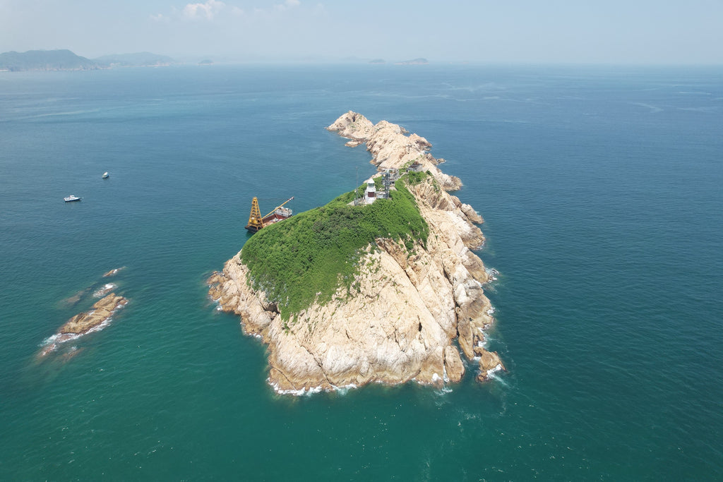
South Ninepin Island 南果洲
"Wherever you watch the sunset, the sun goes down the same way. But many find it beautiful at their location perhaps of the people they were with or nice things that happened on that day. It’s a feeling of great joy. I believe if I capture a sunset shot of South Ninepin Island, I am telling you a story. It would be as if I watched the sunset with you and that's enough for me to savor for an entire year!”
「在任何地方看到的日落都是一樣的,太陽都是這樣下降,但不同人覺得那裡很美,可能是因為當天陪伴在旁的人,可能因為當天發生的事,拼湊而成完美幸福的感覺。如果我現在拍下一張南果洲的日落,我可以說出一個故事,我是跟你一起看的,那都夠我回味一年了」

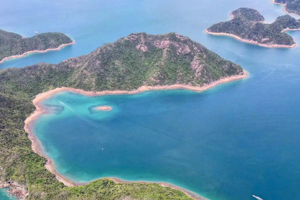
South Ninepin Island or Tung Kwo Chau is in the southeast of Hong Kong. One of the islands located in the Kwo Chau Archipelago, consisting of Tai Chau, Tai Chau Mei and Shan Ling Kok, with North Kwo Chau and East Kwo Chau nearby. As the saying goes, "Admire rocks at North Kwo Chau and marvel at caves at South Kwo Chau". In fact, there are plenty of sea caves, dens, and hollows to see on South Kow Chau, but much depends on the timing, location, and travel companions when you get here. We were blessed with great weather when we visited the island for two days and one night.
南果洲位於香港東南面,是果洲群島其中一個島嶼,由大洲、大洲尾及山嶺角組成,旁邊還有北果洲、東果洲,以上地方我都去過啦,往後再跟大家介紹。俗話說「北果觀岩、南果賞洞」,由於南果洲有大量海蝕洞、隧道、拱門等,要到這裡真的要看天時地利人和,而那兩天一夜我們真是被上帝眷顧的子女!
I checked with the observatory one day before our trip. It forecasted there would be an easterly wind of force 2-3. Conditions perfect to explore caves on South Ninepin Island! It just so happened that SplitdyBoat, the boat hiring and visitor pairing platform we founded in Hong Kong, had a boat going the next day. This time for me and Heng! We packed up and off we went but because we were in such a hurry, a mishap occurred. Read this article to the end to find out what happened! Now when I look back, I am surprised how we survived those two days!
前一天查看天文台,顯示翌日是吹東風2-3級,還不是風平浪靜最適合到南果洲進行洞穴探險嗎?剛好我們創辦的香港夾船平台SplitdyBoat翌日就有船前往,多我和恒兩位不多!我們忙忙收拾行裝準備出發,正因為太急了往後發生悲慘的事,大家一定要看到最後....現在回想,那兩天我們是怎樣撐下去的!
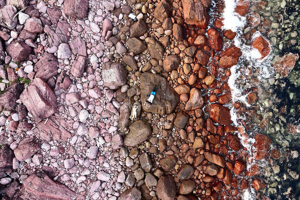
We decided to start from Po Toi O in Clearwater Bay, which is the closest to North and South Kwo Chau and hence the boat fare is the cheapest. We rented a canoe from the local store and the boatman helped to put the canoe onto his speedboat and we were on the island in 15 minutes! The boatman docked at a rocky beach named Ma Wan and let us get off the speedboat. There is in fact a clear path that leads right to the beach. However, as we had a canoe with us, we had to travel by water. We saw some elderly friends who had way too much stuff and so we acted as a water UBER to pick them up! The water quality was good with crystal clear visibility up to 5-8 meters. Facing the beach is the famous Tiger's Mouth Cave, which runs through the center of South Ninepin Island. I wonder how strong do the waves have to be and how long does it take for the cave to erode like this?
我們去清水灣的布袋澳出發,這裡最近南北果洲,所以船費最便宜,我們在該店租借了獨木舟,船家幫我們放上快艇,輕輕鬆鬆15分鐘就到達了。船家停靠在名為媽環的沙灘岩石讓我們下船,只需沿路往上攀一邊,就有清晰的路徑接駁到沙灘。我們有獨木舟當然用水路囉~有些年長的朋友拿了太多東西,我們還充當水上UBER來回接他們一程呢!當天的水質真的好到不行,像玻璃水一樣,能見到達5-8米。沙灘迎面而來是全南果洲最有名的海蝕洞-虎口大洞,貫穿了南果洲的島中心,到底要多強力的海浪,多長的時間才能沖蝕到這樣?

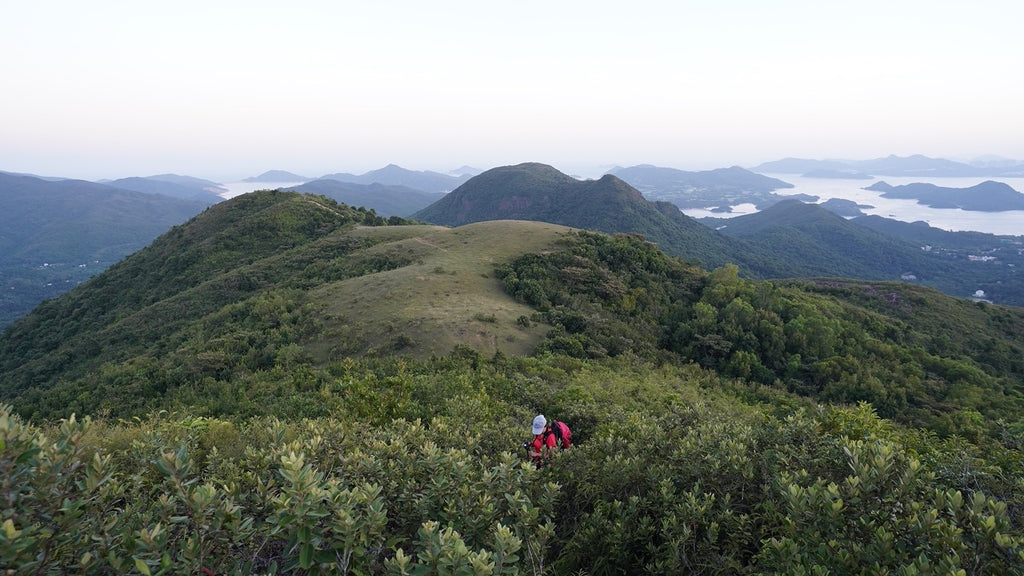
It was probably because the weather was so hot at 34°C that we were losing our bearings. The small grassy area where we would have camped was just a few steps away from the beach. However, we took a wrong turn toward the left side of the rock formation and went in full circle! The hardest part was we had to carry drinking water in our left hand and shower water in our right hand with camping bags on our backs. We were already drenched in sweat just from dragging the canoe onto the beach! All we wanted was to plunge into the water to cool ourselves off. On arrival, the camping site had about 4 or 5 tents backed by Tung Tsui Shan. There is also a Tin Hau Temple at the top of the mountain with some statues for fishermen to worship.
可能是因為當天氣溫度高達34度,我們意識不太清楚,原本可以露營的小草地距離沙灘只是幾步之遙,我們卻走了左邊的岩石,兜了一大個圈!最辛苦是要左手拿飲用水,右手拿沖身水,還背著露營包,單是把獨木舟拖上沙灘,我們已大汗淋漓,狠不得立刻衝下水降溫。露營的位置大概放到4-5個營帳,背靠東嘴山,又稱東心墩,走到山頂有一座天后廟,只有幾個神像,供來往的漁民參拜。
After setting up our tent, we took time to go out and explore on the canoe! We started out on the north side of South Ninepin Island. We passed by a stone chamber along Shek Mei Tau, which could accommodate around 10 people. It seems there is nothing special from a distance, but upon entering, you feel cool inside and could see the door of the Temple from afar. We even joked that this was the only shady spot on the island. We considered spending the night here but believed we would be bitten by mosquitoes all night! If you are not good at water activities, the above route can also be reached on foot.
設好營帳後我們就把握時間出發去獨木舟探索了!我們先往南果洲北面起步,先經過石尾頭旁的石室,可容數十人,遠看沒什麼特別,但進去後感到混身涼快,還可遠眺觀佛堂門。我們還開玩笑說這是全南果洲唯一陰涼的位置,可考慮在此過夜,但相信一定被蚊蟲咬死。如果大家不善長水上活動,以上路線都可登山到達。
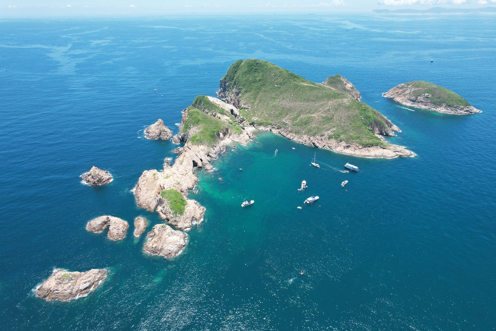
Rowing ahead from the stone chamber, you start to notice many large and small sea caves eroded by nature. On the canoe, you can feel huge currents which could push you away for a few meters and watch waves crash against the rocks at a height of 3-4 meters. It is easy to analyze these caves with modern geography but hundreds of years ago, these strange landforms on the island were depicted in ancient books including the "Ji Yuan Lu" and "Guangdong Fang Zhi" with a story passed down generations about three dragons. According to legend, these three evil dragons caused havoc and disrupted the livelihoods of people in the local community. Later, the Goddess of Tin Hau worshipped by the residents tamed the three dragons. The dragons were scattered around the mouth of the Pearl River, with part of their heads sealed on South Ninepin Island and their bodies in a sea cave. As a modern person, I smiled with respect after hearing this, but after seeing the power of the sea erosion, I began to believe that the forces of nature were scarier than the dragons.
室再向前划,就會開始見到南果洲大大小小的海蝕洞。在海上漂浮著感受到巨浪的沖刷,一來一回的已可把人推開幾米,看著岩石邊一起一落的浪快,高低起跌有3-4米,這一秒看到外露的石頭,下面就被巨浪掩蓋。用現代的地理知識解構這些海蝕洞一目了然,但在幾百年前,南果洲這些奇形地貌在《稽原略》及《廣東方志》等古書有載,流傳了一個關於三條龍的故事。相傳民間有三條龍作惡,生靈塗炭,民不聊生。來後人民信奉的天后娘娘收復了三龍,再將龍體散落珠江口四周,其中一部分的龍頭封印在南果洲,而龍身就是海蝕洞。雖然作為現代人聽後只能尊敬微笑,但見識了海蝕的威力後,我開始有幾分相信它們比龍更可怕。
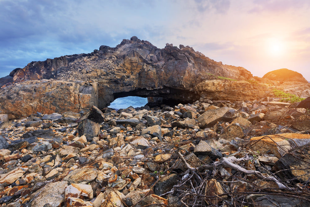
The first thing we saw in front of us was a wind tunnel which looked like a shark's mouth, with long red and greenish rocks on the left and right sides. Imagine its tongue with drops of water dripping down from the top. We were like bait inside a shark's mouth about to be swallowed up! I thought this was the end. It turned out to be a cave of dozens of meters, straight to the other side of the island. If not for the light coming through, I would not have believed it! We entered inside from the far left. Wow, it felt like rafting in a water park, as if we were on a deep adventure. However, this time there was no track underneath, only chaotic rocks against unstructured waves. If we were not careful, we would capsize the canoe! We may enter and never exit! We carefully entered an intersection of the cave and saw the light behind us. To avoid waves from pushing against us, we rushed to the exit on the right which was absolutely thrilling!
面前第一個看到是的迴流洞,外型像一個鯊魚的嘴巴,左右兩旁有鮮紅漸綠的長岩石,像是它的舌頭,上頭看有水珠一滴一滴下來。我們就像它的囊中物,快要被吞噬掉。本以為就這樣呢,原來它是一條長達幾十米的隧道,直通島的另一面,如果不是那一絲光透過來,我還不相信這件事呢!好戲一浪接一浪,兜過一個小圈,我們到達了三叉洞,故名思義就是分開三個出口的海蝕,我們從最左邊的進入,天呀,真有一種在主題公園玩漂流記的感覺,仿佛進行地深探險記,但這次船下沒有軌道,只有雜亂的石頭,無章的海浪,一不小心就翻艇或有入無出的機會。我們小心翼翼的進到洞的分叉口,看到背後的光線,相信就是與迴流洞相通的。為免海浪把我們越退越進,我們趕快從右邊的出口離開,驚險刺激得很呢!

After exploring the cave, we continued to paddle around the island back to the beach, passing the back of the Tiger's Mouth Cave, which was more intimating than the front! Finally, we reached two sides of rows of rock that were tens of meters high and felt like we were in a Jurassic movie. Wow! If this was a huge bird flying in the sky, I would have thought it was a flying dinosaur! Imagine the theme music playing… haha!
經過一翻驚心動魄的洞穴探索,我們繼續圍著島划回沙灘,途經虎口大洞的背面,跟前方比多了一分震撼。最後我們在一對高幾十米的石排中穿駿,又有一種置身於侏羅紀電影的感覺。真的!如果這是有大鳥在天上飛過,我真以為是飛龍呢~背景音樂請響起,哈哈!
Just as we were lying on the canoe waiting for the sunset, I remembered with shock that we didn't bring any gas stove! How are we to cook? On a whim, Heng decided to paddle ahead and ask for help from people on board a nearby yacht but unfortunately, no one had one. They gave us some dried food instead. Luckily, the food we brought this time could be eaten raw. These include tomatoes, corn in a carton etc. We must make do with a vegan meal this time which is going to be healthy for our guts!
正當我們躺在舟上等待日落來臨的時候!糟糕!我記起我們沒有帶瓦斯爐,怎樣煮食?恒靈機一觸,決定提起勇氣划向前方的遊艇客求助,可惜每個人都沒有...只能送我們一些乾糧。幸好我們這次帶來的食物都可以生吃的,如番茄呀~盒裝玉米等等,就來一場蔬菜清腸胃的大餐吧!
After a long day of paddling, we were tired, took a shower and walked to the bottom of Tin Hau Temple to wait for the sunset. I once heard a YouTuber say that he didn't understand why someone compared Hong Kong's scenery to foreign countries. I would have argued with him after hearing this. I would say out loud that Hong Kong is in no way inferior to foreign countries, but I did not. On the contrary, I carefully thought that…
划了一整天我們都累了,用水淋浴後我們走到天后廟下方等待日落。早前聽到一位YouTuber說,他不理解為什麼有人將香港的風景跟外國比較,在他眼中香港拍馬都追不上別人。我聽了這番話理應跟他爭論的,因為我一向都大大聲說香港不輸外國的呀,但我沒有。反而,我仔細思考...
Is it even fair to compare landscapes? Some people say the sunset in Greece is the most beautiful, some say Bolivia, but I say this one on South Ninepin Island in Hong Kong is the most gorgeous!
其實風景是可以比較的嗎?有人說希臘的日落最美,有人說是玻利維亞,而我卻說是眼前這個-香港的南果洲,最美。
"Wherever you watch the sunset, the sun goes down the same way. But many find it beautiful at their location perhaps of the people they were with or nice things that happened on that day. It’s a feeling of great joy. I believe if I capture a sunset shot of South Ninepin Island, I am telling you a story. It would be as if I watched the sunset with you and that's enough for me to savor for an entire year!” said Heng.
「在任何地方看到的日落都是一樣的,太陽都是這樣下降,但不同人覺得那裡很美,可能是因為當天陪伴在旁的人,可能因為當天發生的事,拼湊而成完美幸福的感覺。如果我現在拍下一張南果洲的日落,我可以說出一個故事,我是跟你一起看的,那都夠我回味一年了」恒說。

As the warm sunlight dimmed and replaced by the haze of a red sky, we hugged and gazed at the ever-changing colors of the sky, hoping that this moment would freeze in time.
太陽暖和的光線漸暗,換上漫天紅霞,我們相擁凝視天空不斷不轉變色彩,心中期昐這分秒請停放半刻。
At night, we were the only ones on South Ninepin Island. After dinner, we chatted and heard sounds of the Marine Department patrolling on the sea. Just as we were about to climb into our tent for a rest, Heng stopped me and gestured that the moon behind our backs had secretly risen from sea level right next to Tung Tsui Shan, a sight I had never seen before.
晚上的南果洲只有我們兩,用完晚餐後我們就聊聊天,不時聽到海面傳來海事處巡邏的聲音。正當我們想攀進帳裡休息,恒卻大叫我出來,原來我們一直背對著的月亮,偷偷地從海平面升起,就正正在東嘴山旁,這個景像我這麼大個人還是第一次見。

The next morning, we walked up to the top of Tai Chau Shan to watch the sunrise. Fishing boats sailed by in the reflection of the rising sun's rays. The next day in South Ninepin Island was leisurely. We went snorkeling and laid on the grass looking at Tseung Kwan O, which is dozens of kilometers away. I remember that it was only a few years ago this day, I was dressed in a suit, handing out flyers and chatting with neighbors on the street. Today I am on a deserted island with messy and oily hair and bare feet. The only thing that hasn't changed is that I haven't left here. This place – Hong Kong is my home.
翌日的早上,我們慢條斯理的走上大洲山山頂看日出,魚船在太陽的光線反射下駛過,每分每秒都像一幅油畫。第二天在南果洲的行程就是悠閑,無所事事的去浮潛,或是躺在草上望著距離幾十公里遠的將軍澳,幾年前的這個清晨,我穿得西裝骨骨地在街上派傳單,與街坊聊天,今天的我,卻不理髮絲淩亂油槽,赤腳踏在一個荒島上,唯一沒變的是我沒有離開這裡,這個地方還是我的家-香港。
Photography: @hansleytravel
Continue reading